This week’s post is the beginning of another multi part series that I am sure will keep your interest. It’s a timeline that reveals the creation of Oak Crest, the creation of each street, and some other interesting facts.
The year was 1923 and Winston-Salem was growing westward. The wealthy and affluent families were leaving the city to build big estates in the country. The concrete highway (aka Boone Trail Highway and now Reynolda Rd) that led from town to the country became the corridor for many these estates. The county had just completed a new sand clay road (now east Polo Rd) that began at the concrete highway where the already existing Mount Tabor Rd (now west Polo Rd) intersected. The new road headed east to intersect with Old Town Rd (now University Pky), Rural Hall Rd (now Cherry St), and ending at Walkertown Rd (now Indiana Av).
About 350 yards east of the concrete highway on the sand clay road was a large tract of land owned by brothers J W, F H, and H E Fries. They decided to develop the large tract. The land was divided into 27 large parcels ranging in size from one acre to 16 acres. These parcels were large enough for a nice home as well as raising vegetables and livestock, and yet close enough to neighbors. I believe this development was originally intended for large scale homes (perhaps Buena Vista style) as a continuation of the existing new growth in the area.
This new development was named Oak Crest (perhaps derived from one of the versions listed in last week’s post). The only streets through this development were the sand clay road and one semi circle side street.
Oak Crest Drive – Since the new sand clay road had just been completed and ran through the middle of the Fries Brothers new development, they called this portion of the road Oak Crest Dr.
Friendship Circle – This was the only side street in Oak Crest when it was first developed. Maybe the name was derived from the name of the developers (FRIEs ~ FRIEndship). Lets face it, Fries Circle would not have sounded very attractive. Also, the name Friendship was chosen to imply “a community of friends.”
Below is the the original plat of Oak Crest dated June 1923. This plat indicates the original 27 parcels of Oak Crest. Notice that the land where Crepe Myrtle Circle is now located was not included as part of the original development. Also, notice that the name “Harmon” appears on the south side adjacent to the parcels that are now Harmon Av and Rosedale Cr and the name “Reynolda” appears on the east side adjacent to the parcels that are now Rosedale Cr. That part of Reynolda is now the campus of WFU. Lastly, the long parcel that extends way south is the area that is now Aaron Ln and Belle Vista Ct that is accessible from WFU.
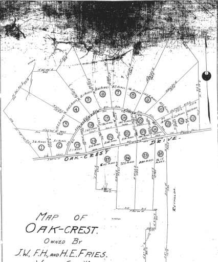
Please note that the bottom portion of this plat is cut off and the top is dark and difficult to read. Also, there is a faint outline of Freds Rd. I mention this for a reason. This was the first copy I had of this plat and I was unsure of two things, the date it was platted and the origin of Freds Rd. Next week I will post the other copy of this plat that is more clear and will answer those two questions.
Click on the plat above to view an expanded version or visit the entire Historic Oak Crest Photo Gallery.