Weekly Acorn #42
This week I am going to tell you about a planned estate that was actually adjacent to Oak Crest (not actually part of the original 27 parcels owned by the Fries brothers), but was never built. I am including it in this series because the site where the estate was to be located is believed to be “The Oak Crest,” which is where the name of our neighborhood was derived.
The location of this property is adjacent to the northern border of Oak Crest and consisted of over 100 acres. The property was purchased by William T. Wilson. However, records for this particular piece of property do not show anything prior to 1942. William Wilson was a prominent figure in Winston-Salem and even served as our Mayor from 1935-1938.
The 1920’s and 30’s was a time when Winston-Salem was moving westward and the concrete Boone Trail Highway (now Reynolda, Valley, and Yadkinville Rds) became a corridor for many of the prominent citizens to build their country estates, weekend homes, and farms away from the city. Family names like Reynolds, Gray, Hanes, Davis, Speas, Cox, Hine, Messrs, Whittington, Angelo, and Newsom just to name a few.
So, it was only fitting that Mayor Wilson wanted to “keep up with the Joneses” and build his grand estate among the rest. However, it was never built. Later the property was sold.
Rebecca Kester Nisbet ended up purchasing the property in August 1942 (earliest recorded purchase of this property) which was adjacent to two large parcels in Oak Crest (parcels 5 & 6) that the Kester’s had already purchased between 1932 and 1938 along both sides of Freds Rd. The Kester’s were also a prominent family in the area which I will discuss in an upcoming multi-part series titled Family Ties.
The Wilson Estate was to consist of a large mansion and formal gardens that would be located on top of the highest peak of the property. This peak is what I refer to as “The Oak Crest.” I also mentioned this in an earlier post (Weekly Acorn #28) and included a photo of an old oak tree that is located at the top of the hill. This oak tree on top of the hill is supposedly where the name Oak Crest originated. However, the tree was quite old and large, so I do not know if Mayor Wilson named the area after it or if possibly the Moravians (or someone else) named it since the old Bethabara to Salem road, that was cut through in 1766, ran right beside the tree.
The estate was to have a grand entrance with a long winding driveway leading up to the mansion and formal gardens. The estate entrance was to be located at the end of Freds Rd. In fact, some of the formal garden area was actually created as well as a beautiful rock entrance and gate to the estate was erected and both are still there today. The masonry of the rock entrance resembles that of the Reynolda estate and the former Davis Estate where Crystal Lake was located (now The Corners At Crystal Lake Apartments). The original rock pilars, walls, and terraces (decks) are still intact at the Apartment complex today.
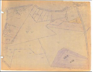
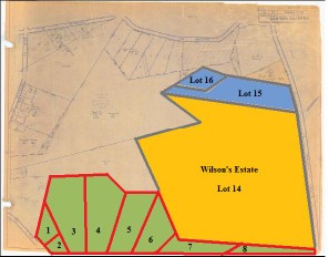
This is the plat (circa 1920’s or 30’s) of the area adjacent to the northern border of Oak Crest. I tried to position it so that “north” was at the top, but instead it is more to the right (note the north “arrow” in the middle of the right border). Because of that the writing is upside down. A color coded version of the same plat (right) illustrates its relation to Oak Crest (green). William Wilson’s estate was lot 14 (yellow). Lots 15 & 16 (blue) were owned by a Henry L Wilson (not sure if related) from 1926 – 1957 and then Lindsay Knox Wilson from 1957 – 1959. Parcels 5 & 6 of Oak Crest (green) is where Freds Rd is located. Lot 14 (yellow) is the approximate location of Silas Creek Pky Ext at Bethabara Rd, the Crowne Oaks Apartments at that intersection, and The Brookridge Retirement Community. Lots 15 & 16 are the location of Edgebrook Dr. Click on the plats above to view an expanded version or visit the entire Historic Oak Crest Photo Gallery.
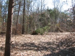
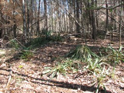
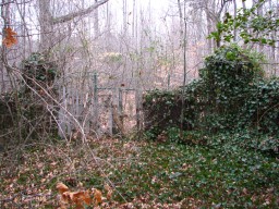
Upper left: top of “The Oak Crest” and approximate location of where William Wilson’s proposed mansion was to be located, upper right: yucca plants that were part of the proposed formal gardens, bottom: rock entrance and gate located at the end of Freds Rd. Click on the photos above to view an expanded version or visit the entire Historic Oak Crest Photo Gallery. These as well as additional photos of the proposed Wilson Estate, house location, formal gardens, and rock entrance are in the Freds Rd and The Oak Crest sections and photos of the same rock masonry in the Crystal Lake section.