Weekly Acorn #45
This week I am concluding the summary of the original 27 parcels of Oak Crest with lots 19-27 and Nading’s Addition. Please keep in mind when reading this that some of these parcels were divided into very small narrow lots with as little as 15-20 feet across the front, so each owner may have several lots containing only one house. The map at the bottom of this post illustrates this very well.
Parcel 19 – This parcel was originally sold as one lot. Then it was split up into six lots with two fronting Friendship Cr and 4 fronting Polo Rd. The parcel now consists of seven lots with one house fronting Friendship Cr and three houses fronting Polo Rd.
Parcel 20 – This parcel was originally sold as one lot. Then it was split into four lots all fronting Polo Rd. The two middle lots each contain houses and the two end lots became additional property for the lots adjacent to this parcel on either side. My house is one of the two houses on this parcel.
Parcel 21 – This parcel was originally sold as three lots all fronting Polo Rd. Then later two of those lots were each split up into two lots for a total of five lots (of varying sizes) on this parcel. The parcel now consists of the five lots with four houses located on them. The smallest lot is part of one of the other lots in the parcel.
Parcel 22 – This parcel was originally sold as three lots all fronting Polo Rd. Then later the middle lot was split into two lots and were added to the lots on either side of them. The parcel now consists of four lots (of varying sizes) with one house and the service station (Campus Gas).
Parcel 23 – This parcel was originally sold as one lot and was part of the farm from parcel 14. Later the parcel was sold and eventually divided into three lots. It now consists of three lots containing three houses all fronting Polo Rd.
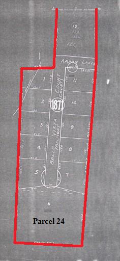
Parcels 24, 25, & 26 – These three parcels were used to create Rosedale Cr and half of Hobart St (formerly Rosedale St). It was first divided into 20 nice sized lots. Later 19 of these lots resubdivided into 123 much smaller lots. The one remaining lot (also the largest and part of parcel 24) was divided into 12 lots and two more streets (Aaron Ln and Belle Vista Ct) were created, but they are only accessible from WFU instead of Rosedale Cr, making them part of another neighborhood now. These two streets now consists of 13 lots containing 13 houses. The rest of parcels 24, 25, & 26 making up Rosedale Cr now consists of 123 lots containing 52 houses with 6 houses fronting Polo Rd and 46 houses fronting Rosedale Cr.
Parcel 27 – This parcel was originally sold to a group of investors who created Harmon Av (originally a boulevard with a center median) and the other half of Hobart St (formerly Rosedale St). It was divided into 47 small lots with 12 fronting Polo Rd and 35 fronting Harmon Av. The parcel now consists of 50 lots containing 15 houses with 4 houses fronting Polo Rd and 11 houses fronting Harmon Av. The median was eventually taken up and Harmon Av is now a single street.
Nading’s Addition – This parcel was owned by brothers H A and J A Nading which they developed into Crepe Myrtle Cr and became part of Oak Crest. The parcel was divided into 74 lots with 10 fronting Polo Rd and 64 fronting Crepe Myrtle Cr. The parcel now consists of 88 lots containing 47 houses with 9 houses fronting Polo Rd and 38 houses fronting Crepe Myrtle Cr. Two houses were demolished on the circle earlier this year.

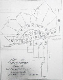
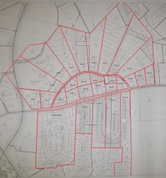
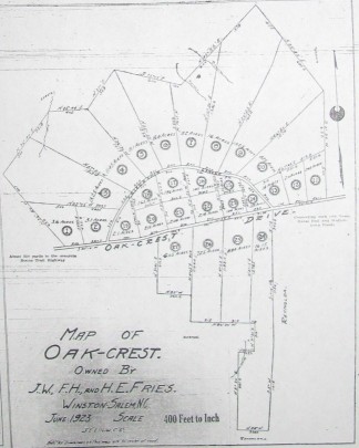
This original 1923 plat and current (2004) map of Oak Crest are shown together here for comparison to illustrate how the original 27 parcels were subdivided including Nading’s Addition which became Crepe Myrtle Cr and part of Polo Rd. The plat on the far right is the continuation of parcel 24 (cut off on the map – middle) which includes Aaron Ln and Belle Vista Ct. Click on the plats and map above to view an expanded version or visit the entire Historic Oak Crest Photo Gallery.
During the next two weeks I will continue this series with some newly discovered information about the subdivisions of Idlewilde Ct and Idlewilde Heath.